Trefriw to Ugly House.
As we have a good deal of local knowledge, and we have walked round the area of Llyn Geironydd on numerous occasions, we thought that this section would be easy...wrong! It also turned out to be a very wet day, beyond that forecast.
The route on the OS17 looks straight forward but we wanted to test the description in the Cicerone Guide to make sure it was still valid. We parked in Betws Y Coed and caught the 10.35am Sunday bus back to Llanrwst and Trefriw. Our Idea was to walk the route from Trefriw as far as the Ugly House on the A5 main road and then return to Betws for a late lunch. All went well with the plan until we arrived in Trefriw and it started to rain.
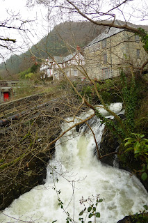
The route out of Trefriw is fairly easy to find as it starts on a side road between a Café and the bus stop opposite the Fairly Falls pub. After a few yards going uphill there is a footpath to the left which leads to a good view of the waterfalls and a small footbridge.

After the footbridge turn right uphill until you reach a T Junction. The guide book had explained the route well until we came out at the T Junction. At this point the guide directs walkers to cross the road and go straight on past a row of houses to a Children's playground. You should then pass through a gate onto an open meadow and basically walk parallel to the river on your right. In reality this path disappears on both the ground and on the OS map.
Our alternative is to turn left at the mentioned T junction and walk for approximately 100 metres until you find a public path on your right entering a wood. The path described by Cicerone supposedly meets this path further up the hillside. Our chosen route is well marked by a local sign scheme "Trefriw 5 "and is the better option and a gradual climb to the lake.
Follow this well defined path uphill until you reach the metalled lake road. The path is pleasant and winds through woods giving views down to the river where the route described in Cicerone should be. (Ignore any joining paths from the left in the woods.).

 You should pass above the old Klondyke Silver mine workings and eventually reach a stile, followed a short time later by a second stile. After the second stile it is only a short walk to the metalled narrow road which runs to the east side of Llyn Geirionydd. The history of the Klondyke Mine is described on an information board in front of a seat nice place to pause to get your breath back ( on a nice day!)
Turn right along the metalled road and head South towards the lakeside.
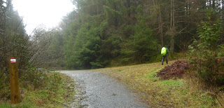
 After a short while you will come to a gate, just after this gate the path you need is on your left over a flimsy stile. The path now goes uphill at about 30 degree angle from the metalled lakeside road. This path is not well defined and, from our knowledge, it can be hidden by ferns in summer; take care not to stray too far uphill. Eventually you will come to a small footbridge with a single tree on the brow in front of you. Head roughly for the tree and you should now be able to see the old mine workings ahead - described in Cicerone and shown on OS -OL17. Cicerone describes walking through the workings but be warned the path has been diverted to the left of the workings and leads to a shale track which heads off to the ENE. Do not take this but turn right and follow the shale track back past the workings until you pass a small cottage with an adjacent timber chalet on your right. Keep on the shale track as it winds past the cottage until it meets the road and then turn left. This is again described in Cicerone but unfortunately the next bit in the guide is best ignored.
Walking along the metalled road the guide book now describes turning left into the woods after a short distance. The signpost for this path still exists but the path does not. The sign post is now marking a new path which goes back diagonally towards where you have just come from. ( Checked with GPS).
Our alternative is to continue to the SSE along the road until you reach a T junction ( having passed the nature reserve on your right). At this T junction turn left and immediate right onto a marked footpath that will take you to a stile and a building on your left (Llidiart y Gwynt). You are now back on the route in Cicerone. Follow the shale track to your right past the buildings until you come to a gate. Ignore the tempting path to your left and pass through the gate and walk towards the next cottage - with a timber outbuilding on your right. This is the Hafoty Pen Craig mentioned in Cicerone. Pass to the left of the cottage and you should be able to see a sign indicating the footpath in front of you. (There is a blog picture of Helen in red looking back at this small sign on a small outcrop.).
Walk across the meadow towards this sign which is on a small brow/outcrop. I suggest you stop here to get your bearings as it easy to miss the next bit as there is a tempting farm track to your right which will lead you astray.
From the path sign look to your left down the hill towards the trees and you will see a ladder stile. This is what you should aim for but the path is indistinct to almost non existent. It is basically South of where you stopped by the sign in the meadow. Having crossed the stile there should be another stile immediately to the left of you. Cross this stile and ignore the narrow path immediately on your right but look ahead and you should see a well defined shale forestry track, join this track and turn right.
The track will narrow and start to descend. Follow this until you reach a gate where you can pause for a moment.
Pause here to decide whether to continue on Sarn Helen, which now doubles back on itself to your right - described as a zig zag in Cicerone. If you are continuing on the trail and your day isn't finished this is the route to take. If like us you needed to return to the delights of Betws Y Coed, then cross the gate and following meadow until you reach a second lane. You can then follow the footpath signposted 8 in blue down to the town. Betws has many shops, cafes, pubs, and places to stay. It also has many outdoor clothing shops to replace kit.
We decided to stop at this point and went for a late Sunday lunch; we were wet and cold - see pictures - and our day and distance had been extended with route finding. Our car was also in Betws. The lunch and pint in the pub made up for it although it did take 2 days to dry our kit out.
This should section should have been a steady walk of about 10 miles to reach the Ugly House but we had completed 8.5 miles (GPS) by the time we reached the gate described above. Some of this mileage will have been taken up with "exploring" routes.
As we have a good deal of local knowledge, and we have walked round the area of Llyn Geironydd on numerous occasions, we thought that this section would be easy...wrong! It also turned out to be a very wet day, beyond that forecast.
The route on the OS17 looks straight forward but we wanted to test the description in the Cicerone Guide to make sure it was still valid. We parked in Betws Y Coed and caught the 10.35am Sunday bus back to Llanrwst and Trefriw. Our Idea was to walk the route from Trefriw as far as the Ugly House on the A5 main road and then return to Betws for a late lunch. All went well with the plan until we arrived in Trefriw and it started to rain.
The route out of Trefriw is fairly easy to find as it starts on a side road between a Café and the bus stop opposite the Fairly Falls pub. After a few yards going uphill there is a footpath to the left which leads to a good view of the waterfalls and a small footbridge.


After the footbridge turn right uphill until you reach a T Junction. The guide book had explained the route well until we came out at the T Junction. At this point the guide directs walkers to cross the road and go straight on past a row of houses to a Children's playground. You should then pass through a gate onto an open meadow and basically walk parallel to the river on your right. In reality this path disappears on both the ground and on the OS map.
Our alternative is to turn left at the mentioned T junction and walk for approximately 100 metres until you find a public path on your right entering a wood. The path described by Cicerone supposedly meets this path further up the hillside. Our chosen route is well marked by a local sign scheme "Trefriw 5 "and is the better option and a gradual climb to the lake.
Follow this well defined path uphill until you reach the metalled lake road. The path is pleasant and winds through woods giving views down to the river where the route described in Cicerone should be. (Ignore any joining paths from the left in the woods.).

 You should pass above the old Klondyke Silver mine workings and eventually reach a stile, followed a short time later by a second stile. After the second stile it is only a short walk to the metalled narrow road which runs to the east side of Llyn Geirionydd. The history of the Klondyke Mine is described on an information board in front of a seat nice place to pause to get your breath back ( on a nice day!)
 Turn right along the metalled road and head South towards the lakeside.
 After a short while you will come to a gate, just after this gate the path you need is on your left over a flimsy stile. The path now goes uphill at about 30 degree angle from the metalled lakeside road. This path is not well defined and, from our knowledge, it can be hidden by ferns in summer; take care not to stray too far uphill. Eventually you will come to a small footbridge with a single tree on the brow in front of you. Head roughly for the tree and you should now be able to see the old mine workings ahead - described in Cicerone and shown on OS -OL17. Cicerone describes walking through the workings but be warned the path has been diverted to the left of the workings and leads to a shale track which heads off to the ENE. Do not take this but turn right and follow the shale track back past the workings until you pass a small cottage with an adjacent timber chalet on your right. Keep on the shale track as it winds past the cottage until it meets the road and then turn left. This is again described in Cicerone but unfortunately the next bit in the guide is best ignored.
Walking along the metalled road the guide book now describes turning left into the woods after a short distance. The signpost for this path still exists but the path does not. The sign post is now marking a new path which goes back diagonally towards where you have just come from. ( Checked with GPS).
Our alternative is to continue to the SSE along the road until you reach a T junction ( having passed the nature reserve on your right). At this T junction turn left and immediate right onto a marked footpath that will take you to a stile and a building on your left (Llidiart y Gwynt). You are now back on the route in Cicerone. Follow the shale track to your right past the buildings until you come to a gate. Ignore the tempting path to your left and pass through the gate and walk towards the next cottage - with a timber outbuilding on your right. This is the Hafoty Pen Craig mentioned in Cicerone. Pass to the left of the cottage and you should be able to see a sign indicating the footpath in front of you. (There is a blog picture of Helen in red looking back at this small sign on a small outcrop.).

Walk across the meadow towards this sign which is on a small brow/outcrop. I suggest you stop here to get your bearings as it easy to miss the next bit as there is a tempting farm track to your right which will lead you astray.
From the path sign look to your left down the hill towards the trees and you will see a ladder stile. This is what you should aim for but the path is indistinct to almost non existent. It is basically South of where you stopped by the sign in the meadow. Having crossed the stile there should be another stile immediately to the left of you. Cross this stile and ignore the narrow path immediately on your right but look ahead and you should see a well defined shale forestry track, join this track and turn right.

The track will narrow and start to descend. Follow this until you reach a gate where you can pause for a moment.
Pause here to decide whether to continue on Sarn Helen, which now doubles back on itself to your right - described as a zig zag in Cicerone. If you are continuing on the trail and your day isn't finished this is the route to take. If like us you needed to return to the delights of Betws Y Coed, then cross the gate and following meadow until you reach a second lane. You can then follow the footpath signposted 8 in blue down to the town. Betws has many shops, cafes, pubs, and places to stay. It also has many outdoor clothing shops to replace kit.
We decided to stop at this point and went for a late Sunday lunch; we were wet and cold - see pictures - and our day and distance had been extended with route finding. Our car was also in Betws. The lunch and pint in the pub made up for it although it did take 2 days to dry our kit out.
This should section should have been a steady walk of about 10 miles to reach the Ugly House but we had completed 8.5 miles (GPS) by the time we reached the gate described above. Some of this mileage will have been taken up with "exploring" routes.
No comments:
Post a Comment